Parcel Boundary Implementation for Android Applications
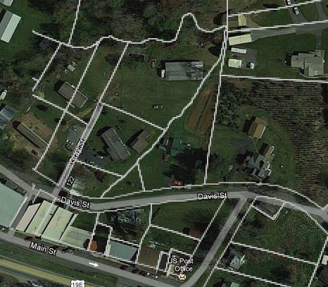
Parcel Boundary Implementation for Android Applications Parcel Boundary Implementation for Android Applications Parcel boundaries are the precise GIS (Geographic Information System) coordinates of a piece of property. Overlaid on top of a satellite or aerial image, they show a mapped image of the exact boundaries of a lot. They allow a potential real estate buyer to "walk" the boundaries of a piece of property from an online map, seeing its proximity to streets and highways, distance from neighboring homes, and access to green space, streams and wooded areas. Below diagram represents how parcel boundaries are plotted on the map. Parcel boundaries do more than just provide a "bird’s eye view" of a piece of property. Once the GIS coordinates of a property are loaded into a map-based platform, they can be combined with additional data sets like school districts, neighborhood demographics and other location information. Governments use par...